
Residents will get a chance to see plans for two planned communities that will bring more than 40,000 new residents to Clarington over the next quarter-century at a public meeting Thursday.
The draft Courtice Transit-Oriented Community Secondary Plan is a vision for a mostly undeveloped area that will feature the future Courtice GO Station and the surrounding Protected Major Transit Station Area, with six elementary schools, two secondary schools, more than 8,000 jobs and nearly 30,000 residents planned for the new community.
The draft Soper Hills Secondary Plan is promising an estimated 5,250 residential units to be accommodated, with 30 per cent affordable, on lands that are currently agricultural fields and single detached dwellings, institutional uses and the Soper Creek valley lands.
Both planned communities are part of Clarington’s pledge to build 13,000 new residential units by 2031.
The Bowmanville East (Soper Hills) Landowners Group covered the cost for the Soper Hills study, which began in 2018. An update on the plan was provided to the public on April 10.
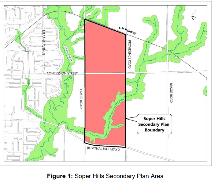
The area on Bowmanville’s east side is bounded by Highway 2 to the south, Lambs Road to the west, the CPR tracks to the north and Bennett/Providence Road to the east.
The 193-hectare area is designed with higher densities and opportunities for transit-oriented development along Highway 2 and medium densities along the boundary roads (Lambs Road and Providence Road) as well as Concession Street. A neighbourhood centre, a community park, three neighbourhood parks and two parkettes are proposed.
The Courtice Transit-Oriented Community Secondary Plan was also originally initiated in 2018 and was bumped up in importance when the province finally announced that four new GO stations were coming to Durham Region, including one in Courtice.
The lands, bounded by Bloor Street to the north, Highway 401 to the south, Robinson Creek to the west and Tooley Creek and Highway 418 to the east, need to achieve a minimum density of 150 people and jobs per hectare to support transit service.
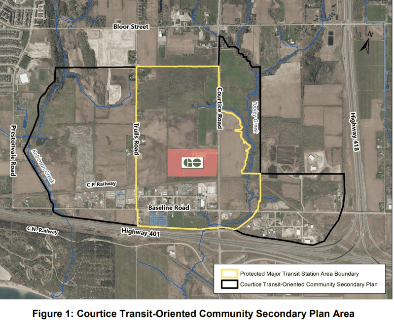
The area is envisioned to evolve as a complete and sustainable community that will have a mix of housing, employment and community amenities and is “well-suited” to accommodate medium and high-density housing that is accompanied by active commercial streets, community amenities, green spaces and a connected network of streets, trails and transit.
The lands located around the future Courtice GO station will be the area for the highest density of development, the tallest buildings and the greatest range of uses. This will be the place to find a variety of options for housing, working, shopping, dining and entertainment. Development will be less intense at the edges of the core.
The area is planned to accommodate close to 30,000 residents, density that is supported by direct connections to the station that encourage the use of transit for daily trips.
Public engagement included four Public Information Centres held between 2019 and 2023 and landowner workshops held throughout the process.
The public meeting for both plans will be held online or in person in the council chambers at Town Hall on Thursday, beginning at 6:30 p.m.
INsauga's Editorial Standards and Policies
PollView All
WIN A $100 GIFT CARD
Subscribe to INsauga’s daily email newsletter for a chance to win a $100 Amazon gift card.