
UPDATE: See an updated forecast for Friday here.
Parts of southern Ontario are getting hit with a winter storm Wednesday and another system could be coming to part of the region to cap off the work week.
Environment Canada’s significant weather outlook for Friday calls for various types of precipitation depending on the location, though it appears there is still some uncertainty regarding the forecast.
For parts of the Greater Golden Horseshoe and portions of southwestern Ontario — area “A” on the map below — freezing rain followed by rain is currently expected.
It could cause icy surfaces as well as flooding in low-lying areas.
“Precipitation is expected to begin as freezing rain or snow Friday morning and transition over to rain through the afternoon,” Environment Canada said for those areas.
“Currently, there are a number of solutions possible for ice build-up and rainfall amounts. Some minor ice build-up is possible with total precipitation amounts, which includes rain and freezing rain, of 10 to 15 mm possible.”
-
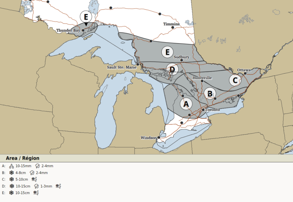
- The significant weather outlook for Friday. (Environment Canada)

Further north, for eastern parts of the Greater Golden Horseshoe and southern parts of central and eastern Ontario (location “B” on the map), freezing rain or snow is expected to start near midday Friday before a transition to snow in the evening.
“Currently, there are a number of solutions possible for ice build-up and snowfall amounts,” forecasters said.
“Some minor ice buildup is possible with total snowfall amounts of 4 to 8 cm possible.”
Parts of central and eastern Ontario, including the Ottawa area (location “C”), are expected to see snow starting Friday afternoon. Total amounts of 5 to 10 cm are possible there.
And for location “D” on the map, freezing rain or snow is expected around midday Friday with a transition to snow through the afternoon.
“Some minor ice build-up is possible, mainly for areas near Georgian Bay and the North Channel as well as for Manitoulin Island, with total snowfall amounts of 10 to 15 cm possible,” Environment Canada said.
Lastly, parts of northeastern Ontario (location “E”) are expected to see just snow, with amounts of 10 to 15 cm in the forecast.
Gusty winds could cause localized blowing snow in areas that see snowfall.
PollView All
WIN A $100 GIFT CARD
Subscribe to INsauga’s daily email newsletter for a chance to win a $100 Amazon gift card.