
VIDEO: A look at a huge and developing waterfront oasis in Mississauga
Published February 18, 2020 at 9:17 pm
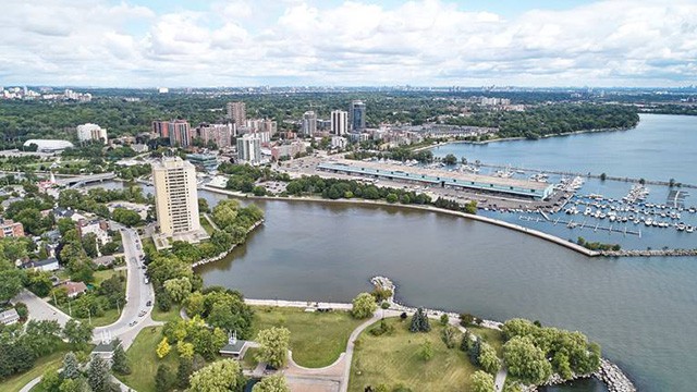
When it comes to embracing development and pursuing urbanization, Mississauga has been one of the more ambitious GTA municipalities.
Not content with remaining a sprawling bedroom community, the city of over 700,000 people has moved forward on a number of placemaking projects and is, most notably, working on completely redeveloping its waterfront through its Lakeview Village and Port Credit West Village (or Brightwater) projects.
Recently, Credit Valley Conservation (CVC) released a video documenting the progress being made at the developing Jim Tovey Conservation Area, which is part of the Lakeview Village project.
You can see the video below:
Named after the late city councillor who drove the ambitious project forward, the area—which is being created by Credit Valley Conservation (CVC), the Region of Peel and Toronto and Region Conservation Authority—will feature what has been called “a beautiful and naturalized conservation area.”
Videos


But the Lakeview neighbourhood isn’t the only part of Mississauga that’s about to get a facelift.
In January 2019, the city announced that it had refreshed its overall waterfront parks strategy. The city says the most significant changes for the 2019 refresh include new parkland, as well as a new large naturalized landscape created as part of the aforementioned Jim Tovey Lakeview Conservation Area.
According to CVC’s video, the organizations responsible for the ambitious eco-project are creating islands to protect the new shoreline and reusing concrete from the former Lakeview Power Generating Station to create new shoreline. The video says three new coastal wetlands have been created.
The goals of the project, as stated in the video, include increasing the wildlife habitat area, adding thousands of plants, shrubs and trees, restoring Serson Creek, encouraging the ongoing formation of an emerging underwater ecosystem, and creating meadow habitats for pollinators and other wildlife.
The conservation area will boast 3.5 km of recreational trails and a cobble beach to provide access to the water. The video also says it will feature 4.6 hectares of forest, a revitalized waterfront and “an oasis to reconnect with nature.”
The conservation area should be open by 2025.
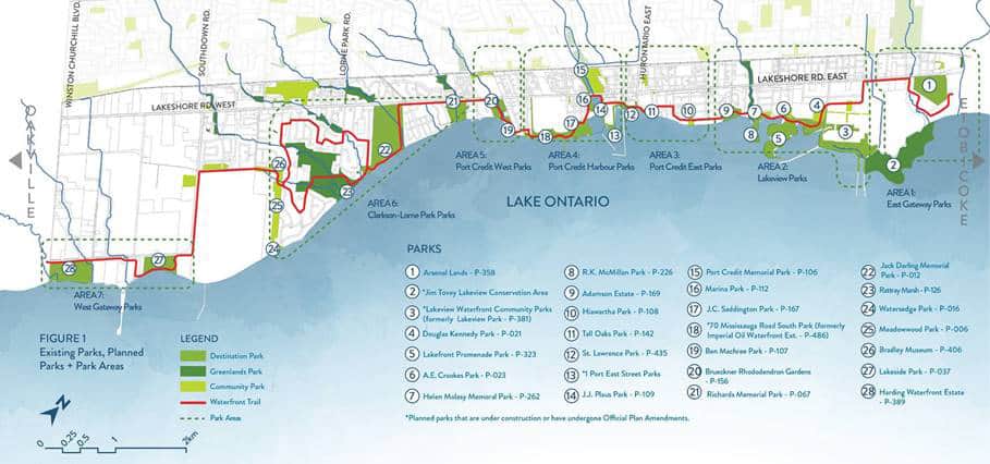
The conservation area is part of the overall waterfront parks strategy, a 25-year vision for city parks along Mississauga’s 22 kilometres of waterfront along Lake Ontario.
The city says the strategy promotes the protection and enhancement of Mississauga’s waterfront while giving residents access to the water–something that will ultimately benefit the city by increasing recreation opportunities and tourism.
The focus on waterfront redevelopment makes sense, as proximity to a grand body of water (Lake Ontario) is a terrible thing to waste–and the city’s prime lakeside real estate has been underutilized for far too long, especially since the land is no longer needed to serve industrial uses exclusively.
“For decades, a large part of Mississauga’s waterfront was a hub for heavy industry with limited access for the public. Over the years we’ve worked to build parks and create public spaces for everyone to enjoy. Our work is only just beginning. This 25-year strategy aims to further reclaim our waterfront and ensure it remains accessible to residents for generations to come,” said Mayor Bonnie Crombie in a statement.
“People are drawn to the water and Mississauga is in the envious position of having 22 kilometres of shoreline. It’s important we not only protect this precious resource, but also promote it. We will do this by seamlessly connecting our existing and new parks with a continuous waterfront trail that connects to our neighbours, and ensuring that all future development prioritizes access to the water.”
The city says the refresh builds on the 2008 strategy and addresses current planning trends and intensification along the waterfront. As well, the strategy encourages the implementation of north/south cycling connections to Lakeshore Road and beyond with paths linking to Toronto and Oakville, and the waterfront trail closer to the Lake Ontario shoreline.
The city also says the strategy will address climate change, intensification and brownfield development along the waterfront, and increased recreational opportunities (boating, fishing, and swimming). It will also increase the city’s appeal to residents and visitors alike.
“The strategy provides a comprehensive plan to preserve, protect and enhance the waterfront park system for present and future generations,” said Jodi Robillos, director, Parks, Forestry and Environment, in a statement.
“Each waterfront park has its own character and provides a unique waterfront experience that includes different views of the lake, trail use, nature and heritage appreciation as well as special programs.”
The city’s refreshed plan went to council for final approval on Feb. 5
Photos courtesy of the City of Mississauga. Video courtesy of Credit Valley Conservation.
insauga's Editorial Standards and Policies advertising