
Thunderstorms coming as heat warning still in effect in Mississauga and Brampton
Published June 26, 2022 at 7:15 am
The temperatures are remaining hot and humid as possible active weather is on its way to Mississauga and Brampton today (June 26).
There is still a heat warning in effect for the Peel Region. The heat event continues today and will end later tonight.
Temperatures are expected to physically reach the mid 30s today but humidex values increase real-feel temperatures to a high of 39 degrees Celsius.
Hot and humid air can also bring deteriorating air quality and can result in the Air Quality Health Index (AQHI) approaching the high-risk category.
There will be rain and a chance of thunderstorms shortly before 3 p.m. that will stick around until about 10 p.m.
The main threats with these storms include heavy downpours, strong and gusty winds and small hail.
Videos


Winds of 70-90 km/h are expected with 20-40 mm of rainfall. 1 cm of hail is also possible for the Golden Horseshoe.
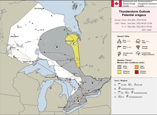
Thunderstorm outlook for Sunday, June 26. Image courtesy of Environment and Climate Change Canada (ECCC).
Loose objects may be tossed by the wind and cause injury or damage. Heavy downpours can cause flash floods and water pooling on roads.
The heat event is expected to break Sunday night with the passage of a cold front.
During h0t weather conditions, there is a greater risk for young children, pregnant women, older adults, people with chronic illnesses and people working or exercising outdoors.
Environment Canada recommends drinking plenty of water even before you feel thirsty and seek shade or a cool place.
Always check on older family, friends, and neighbours and make sure they are cool and drinking water.
Never leave people or pets inside a parked vehicle, even with the windows down, during a heat event like this.
insauga's Editorial Standards and Policies advertising