Snow and frigid temperatures expected every day this week in southern Ontario
Published November 26, 2023 at 6:00 pm

Ontario residents in Mississauga, Brampton, Halton, and Hamilton areas are urged to brace for even colder temperatures this week, with a mix of snow and rain.
The weather last week appeared relatively mild, featuring below-freezing temperatures and a combination of rain, snow, overcast skies, and was occasionally interrupted by sunny breaks. However, a notable shift will bring turbulent weather over the next seven days
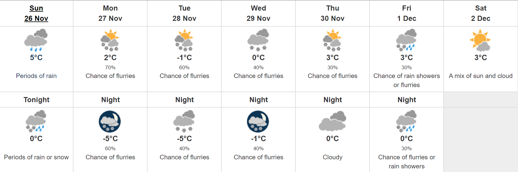
According to the Weather Network, today (Nov. 26) a low-pressure system is anticipated to enter the Great Lakes bringing cold rain to the region, while areas further north may experience wet snowfall. There will be a daytime high of 5 C with occasional cloudy periods and a 40 per cent chance of rain or snow. Rainfall will taper off around midnight, leaving a cloudy sky with a 30 per cent chance of flurries. As temperatures dip to -6 C in the evening, winds from the southwest will intensify, reaching 40 km/h, making it the coldest day of the week.
On Monday, it be will be predominantly cloudy with a 30 per cent chance of flurries, increasing to 70 per cent in the afternoon. The daytime high will reach to plus 2, and as the evening approaches, the cloud cover will persist with a 60 per cent chance (very likely) of flurries and a low of -5 C.
Meteorologists call for a similar weather pattern for Tuesday with a mix of sun and clouds and a 60 per cent chance for snow. Temperatures will reach a high of -1 C and as the day proceeds, will gradually fall to a chilly -5 C. Cloudy conditions will remain throughout the evening with a 40 per cent chance of flurries.
Environment Canada predicts a mostly cloudy day on Wednesday where temperatures will remain at a consistent zero degrees. There is a 40 per cent chance of flurries throughout the day spanning into the late evening. Temperatures will drop to a low of -1 C.
Videos


Later in the week, the polar vortex’s descent over Hudson Bay is set to intensify the lake-effect snow event leading to localized heavy accumulation, reduced visibility, and the potential for travel disruptions or road closures, The Weather Network notes.
Slightly warmer temperature make a comeback on Thursday with a high of 3 C with intermittent sunshine. There is a 30 per cent probability of snow during the day which will clear up by the evening. Temperature will hit freezing while the night sky will remain cloudy.
Friday will be fairly cloudy with 3 C temperatures and a 30 per cent possibility of either rain or flurries, which will continue through the night as 0 C temperatures set in.
Looking ahead to Saturday, sunshine will return with a mix of cloudy conditions. Temperatures will climb as high as 3 C where it will stay for the greater part of the day.
Despite the wintry conditions, a return to seasonal or slightly above-seasonal temperatures is expected by the week’s end.
Environment Canada has not released any weather alerts or advisories for the impending forecast in southern Ontario. However, residents are encouraged to stay informed for additional updates.