

Parts of Ontario could see some active weather over the next couple of days.
Environment Canada has issued thunderstorm outlooks for Monday and Tuesday, warning of a risk of storms.
Here is a look at what forecasters say is expected:
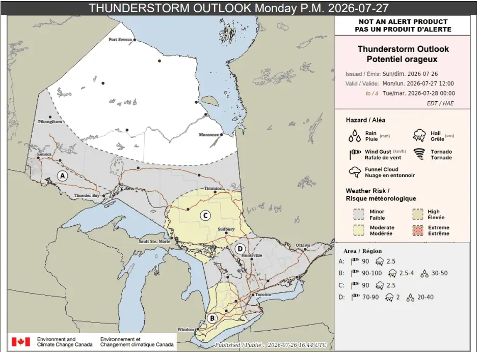
Monday p.m.
In portions of southwestern Ontario, including Windsor and London (location B on the map below), isolated or scattered thunderstorms could happen Monday afternoon and evening.
“Some of these thunderstorms may become severe and could produce wind gusts up to 100 km/h, rainfall amounts up to 50 mm and hail up to 4 cm in diameter,” forecasters said.
Downed trees, power outages, flooding, property damage, and injuries are all possible.
A bit further north, other parts of southern Ontario (location D), including the Greater Toronto Area, could also see isolated or scattered thunderstorms in the afternoon and evening.
“Some of these thunderstorms could produce rainfall up to 40 mm, wind gusts up to 90 km/h and hail up to 2 cm in diameter,” Environment Canada said for those areas.
Location C on the map, which includes Sault Ste. Marie and Sudbury, is expected to see scattered thunderstorms. They could bring up to 30 mm of rain locally, hail that is 2.5 cm in diameter, and winds up to 90 km/h.
And location A, which covers part of northwestern Ontario including Kenora and Thunder Bay, might see active weather as well.
“There is low confidence in the development of thunderstorms, however any that do develop could produce hail up to 2.5 cm in diameter and wind gusts up to 90 km/h,” forecasters said for those places.
Other areas shaded in grey on the map, which includes portions of northern and southern Ontario, including Kingston and Ottawa, have a risk of isolated thunderstorms with 15 to 25 mm of rain.
Tuesday
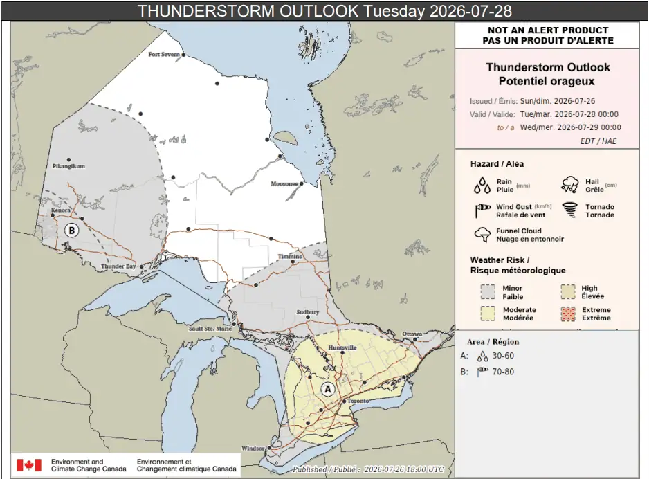
On Tuesday, there is once again a risk of thunderstorms in parts of the province.
Location A below, which covers most of southern Ontario including the Greater Toronto Area, Hamilton, Niagara Region, Barrie, and cottage country, is expected to see scattered thunderstorms.
“These thunderstorms could produce rainfall up to 60 mm, with locally higher amounts possible, but there is still high uncertainty on the exact location of these higher precipitation amounts,” Environment Canada said.
Part of northwestern Ontario (location B), could see thunderstorms in the afternoon and evening with wind gusts up to 80 km/h and up to 30 mm of rain.
Other areas just shaded in grey, including parts of northern and southern Ontario, could see isolated thunderstorms with up to 30 mm of rain.
Maps via Environment Canada
PollView All
WIN A $100 GIFT CARD
Subscribe to INsauga’s daily email newsletter for a chance to win a $100 Amazon gift card.