
A powerful winter storm expected to move through Ontario late Sunday into Monday could rapidly intensify, bringing hazardous weather to much of the province.
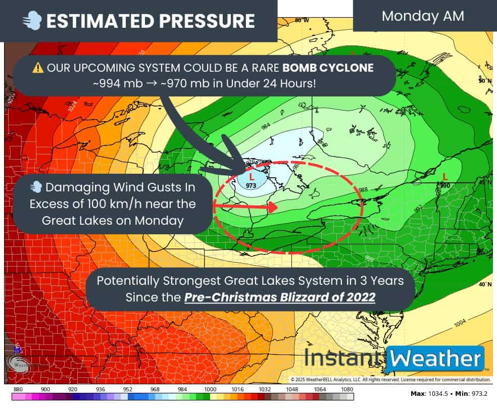
Instant Weather Ontario said in a social media post on X (formerly Twitter) on Saturday that the system could strengthen very quickly as it tracks through the Great Lakes. This process is known as a “bomb cyclone” and occurs when a storm intensifies over a short period of time.
The weather service said this type of rapid strengthening is often associated with severe weather, including strong winds, heavy snow and widespread impacts.
Instant Weather also pointed to upgraded forecasts from Environment Canada, which indicate a heightened risk of blizzard conditions, damaging winds and significant snowfall across parts of Ontario. Areas of freezing rain and the potential for a flash freeze are also possible.
According to Environment Canada, parts of the Golden Horseshoe, including Mississauga, Brampton, Halton, Hamilton and Durham, are likely to be affected, though conditions will vary by location.
Additionally, meteorologists advise of a risk of freezing rain transitioning to rain Sunday afternoon and evening, followed by strong winds and cold temperatures on Monday. These conditions could lead to icy roads and localized power outages.
Wind speeds of 70 to 100 km/h are possible, particularly near Lake Ontario. Rainfall totals of 20 to 40 millimetres could also lead to localized flooding in low-lying areas before temperatures drop.
As colder air moves in behind the storm system, icy surfaces and blowing snow are expected to develop across parts of southern Ontario on Monday.
Snow squalls may develop later in the day and continue into Tuesday, especially east of Lake Huron and Georgian Bay, Environment Canada said.
Instant Weather Ontario noted on its website that while the most extreme snowfall totals approaching 50 centimetres are more likely in northern Ontario, southern Ontario and the GTA could still see significant travel disruptions due to ice and wind.
Forecasters say additional updates are expected as the storm system develops.
PollView All
WIN A $100 GIFT CARD
Subscribe to INsauga’s daily email newsletter for a chance to win a $100 Amazon gift card.