Rain expected to continue into early part of week in Mississauga, Brampton
Published August 21, 2022 at 6:45 pm

A severe thunderstorm warning is currently in effect for Mississauga and Brampton residents as rainstorms persist this week in the region.
This severe thunderstorm is located over Brampton and southern Caledon region and is nearly stationary.
The radar indicates that some areas have already received near to 40 mm of rain with heavy rainfall of 50 mm per hour predicted.
Total rainfall in excess of 50 mm will be possible for areas of north Brampton and southern Caledon region from this thunderstorm.
Severe thunderstorm warnings are issued when imminent or occurring thunderstorms are likely to produce or are producing one or more of the following: large hail, damaging winds, torrential rainfall.
Heavy downpours can cause flash floods and water pooling on roads. If visibility is reduced while driving, turn on vehicle headlight and maintain a safe following distance.
Rapidly rising rivers and creeks can sweep away bridges, culverts, buildings, and people. Avoid driving through water on roads. Watch for possible washouts near rivers, creeks, and culverts.
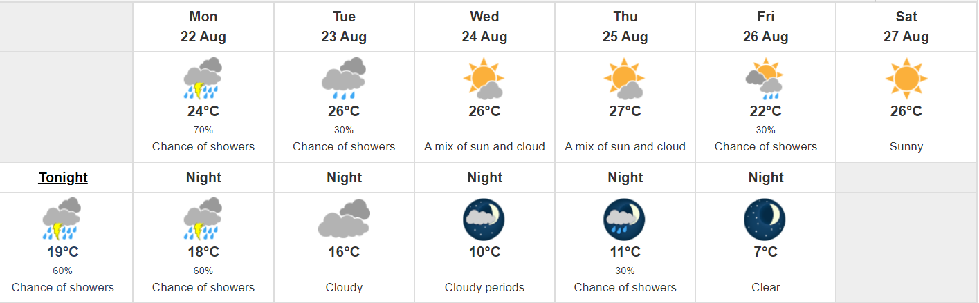
Residents in Mississauga and Brampton should expect the continuation of scattered thunderstorms early this week with the sun making an appearance by mid-week.
Monday (Aug 22) will have a high of 24 degrees Celsius and a 70 per cent chance of showers.
The chance of showers lessens slightly for Tuesday (Aug 23) with a 30 per cent chance and a high of 26 degrees Celsius for the day.
Wednesday is expected to finally bring the sun with a mix of sunny and cloudy skies and a high of 26.
The end of the week may get a little wet again as Thursday has a mix of sun and clouds but Friday (Aug 26) brings a 30 per cent chance of showers.