

A heat wave is set to move into parts of Ontario.
Environment Canada has issued significant weather outlooks for the next few days which say that hot weather is expected with humidex values up to 40 in some areas.
A four-day “heat event” is expected in northwestern areas of the province beginning on Saturday, but it’s also expected to get very warm in southern Ontario at the start of next week.
Here’s a look at what’s expected:
Saturday
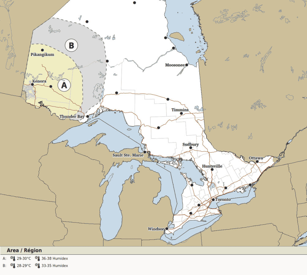
Portions of northwestern Ontario, including Kenora (location A on the map below), will see a “heat event” begin which will continue into Tuesday, Environment Canada said.
“Daytime maximum temperatures of 29 to 30 C and overnight minimum temperatures near 18 C are expected. Humidex values in the mid-to-high thirties are likely,” forecasters said.
Location B on the map may also see the heat event begin, with highs of 28 C to 29 C and humidex values in the low-to-mid 30s.
Cooler minimum overnight temperatures near 16 C will provide some relief, however.
Sunday
Come Sunday, heat will become more widespread throughout northern Ontario.
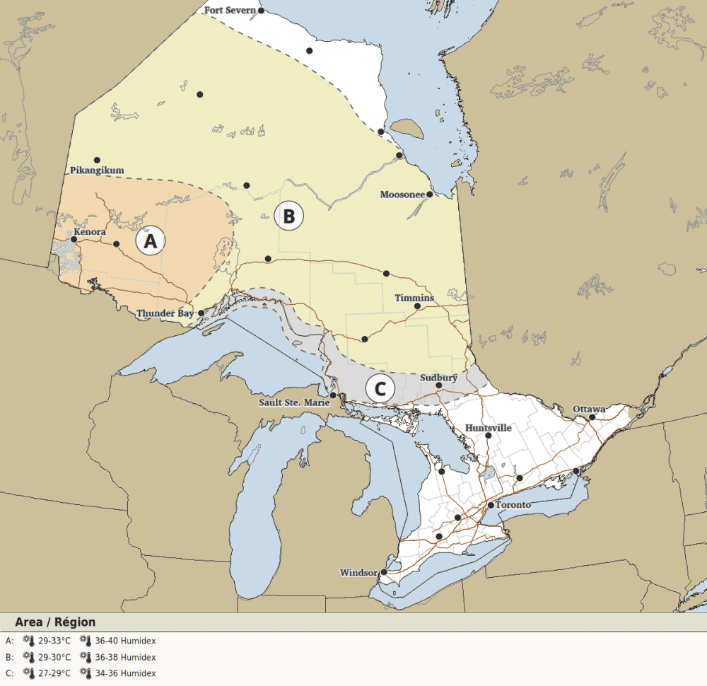
Location A on the map, which once again includes Kenora, will see high temperatures of 29 C to 33 C.
Humidex values are expected to reach the high 30s or low 40s, Environment Canada said.
Overnight lows are expected to be around 20 C.
Most of northern and far northern Ontario (location B) is expected to see hot temperatures begin and continue into Tuesday.
Highs of 29 C to 30 C, with humidex values in the mid-to-high 30s, and an overnight low around 18 C is expected there on Saturday.
Location C highlighted in grey, which includes Sault Ste. Marie and Sudbury, could see a heat event begin. Highs of 27 C to 29 C with humidex values in the low-to-mid 30s are currently expected.
Cooler overnight lows of around 15 C may occur.
Monday
On Monday, parts of southern Ontario will start to see hot temperatures as well.
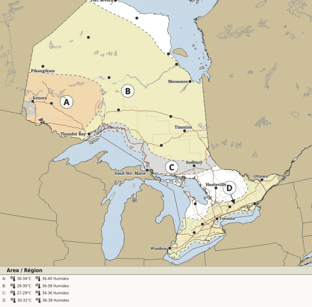
That includes Ottawa, south through the Greater Toronto Area, to Windsor (location D on the map).
“A heat event is likely to begin and continue into Tuesday,” forecasters said for those places.
“Daytime maximum temperatures near 31 C and overnight minimum temperatures near 20 C are expected. Humidex values in the mid-to-high thirties are likely.”
Meanwhile, it will be even hotter in northwestern Ontario (location A), where the heat wave will continue.
Highs of 30 C to 34 C are in the forecast there with humidex values in the upper 30s to low 40s.
Overnight lows are expected to be near 20 C.
Most of northern Ontario (location B) will see highs of 29 C to 30 C with humidex values in the mid-to-upper 30s and overnight lows near 18 C.
And location C, which again includes Sault Ste. Marie and Sudbury, currently has highs of 27 C to 29 C in the forecast with humidex values of 34 to 36.
But rain in the afternoon could “moderate” temperatures there, forecasters said.
Tuesday
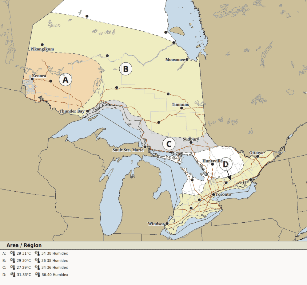
It will once again be hot in southern Ontario on Tuesday, including in Ottawa, the GTA, Hamilton, Niagara, and Windsor (location D).
Highs of 31 C to 33 C are expected with humidex values in the high 30s or low 40s.
Overnight temperatures will be near 20 C.
The heat may continue in those areas into Wednesday.
Northwestern Ontario (location A) will see hot conditions again with temperatures of 29 C to 31 C, though it will feel more like the mid-to-high 30s.
Most of northern Ontario (location B) is expected to see highs of 29 C to 30 C with humidex values in the mid-to-high 30s.
And location C might see highs of 27 C to 29 C, with it feeling more like the low-to-mid 30s.
Maps via Environment Canada
INsauga's Editorial Standards and PoliciesPollView All
WIN A $100 GIFT CARD
Subscribe to INsauga’s daily email newsletter for a chance to win a $100 Amazon gift card.