
Mississauga moves forward with plan to completely transform two parks into waterfront destinations
Published March 4, 2020 at 7:41 pm
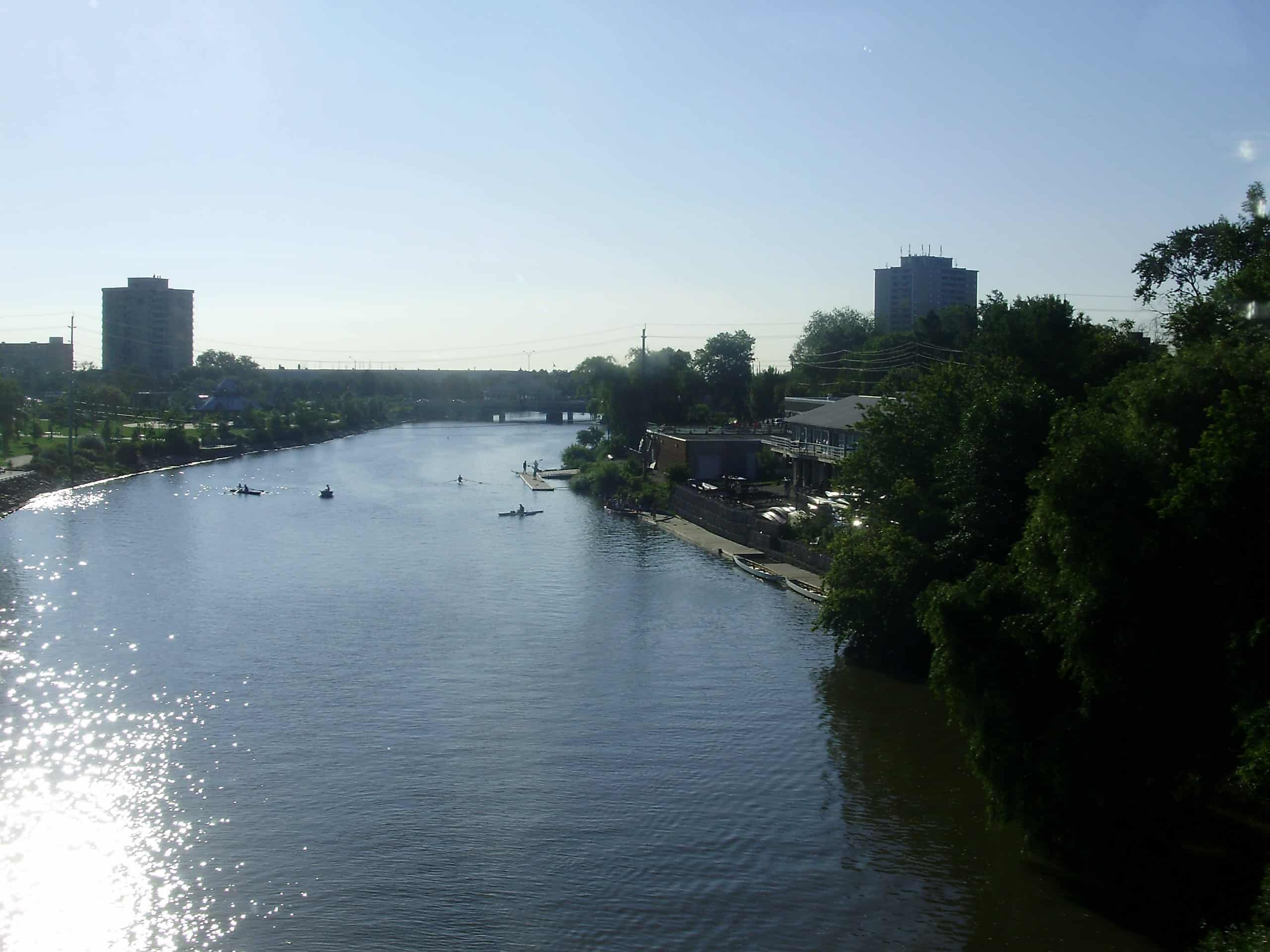
Those who love boating and fishing might already consider themselves fortunate to live in a city that offers access to both Lake Ontario and the Credit River, but many have complained–with good reason–that the city has yet to make the most of its waterfront.
Fortunately for those residents, the city is working to transform its vast waterfront through its ambitious Brightwater and Lakeview Village projects, as well as through some smaller–but still significant–park-focused plans.
On March 3, 2020, the city held a meeting to update residents on the progression of its proposed plans to transform the west bank of Port Credit Harbour into a “vibrant and functional” waterfront destination.
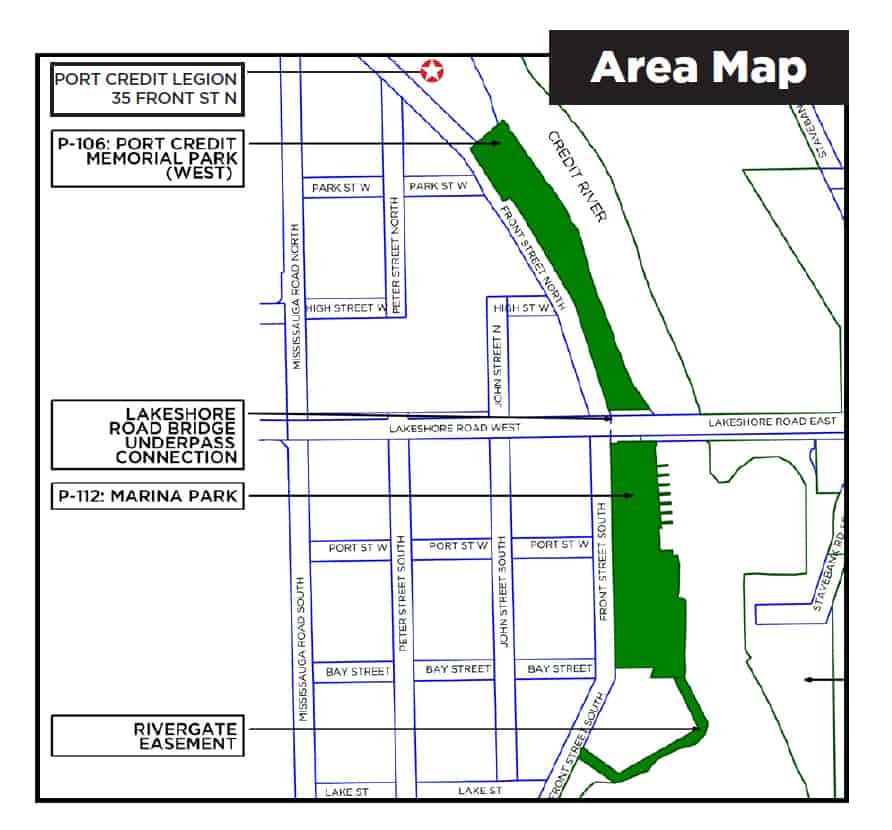
The Port Credit Harbour West Parks project aims to transform Port Credit Memorial Park (west) and Marina Park into sleek, modern and recreation-friendly waterfront spaces. The project area also includes the Lakeshore Road bridge underpass connection and the Rivergate easement.
The city says the plans call for programmable, multi-use space, open green space, a continuous water’s edge promenade, and more.
Videos


The city also said that improvements to the land will also be made to support the working port, as it’s an important piece of Port Credit’s history and the proposed site sits in a heritage district.
At the meeting, which included a presentation by Dillon Consulting Ltd. representatives, planners were candid about some of the challenges inherent in bringing this ambitious project to fruition.
Some challenges include a deteriorated coastal edge, site flooding (planners emphasized the need to create a “resilient” park), congestion caused by various people attempting to access the water for a variety of aquatic activities, deteriorated launch ramps for boats, and the need to separate the launching areas for motorboats and kayaks or canoes.
Some solutions posed by planners included raising the site above flood elevations, creating a walkway under Lakeshore Rd., reconstructing launch ramp facilities, and adding non-motorized launch facilities.
So, what will each park–which will ultimately be connected–look like?
Marina Park
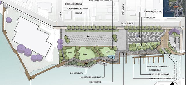
According to the city, Marina Park, which runs along the Credit River, will feature a river promenade along the water’s edge that will be ideal for strolling. It will boast seating/gathering areas and lookout points (including the future Credit Valley Trail) at the river’s edge.
The city says it will retain the current charter boat area and provide a security gate that accesses the ramp and main floating dock spine. The site will feature redeveloped launch ramps for motorized boats, as well as a launch ramp for non-motorized boats.
Visitors can expect flexible car parking and multi-use event space in the north end for fishing, boating, park activities and special events.
The plan will allow for vehicular access on the river promenade, opposite the charter boat docks. The city says car/trailer parking will be improved as well.
The city says the plan calls for walkway connections and new trees throughout the raised green terrace between the car parking lot and charter boat docking area. The project also plans to reduce roadway width and maintain on-street parking on the east side of Front Street South.
There will be some streetscape improvements and an east boulevard that will include a multi-use Waterfront Trail, new street lighting, and relocated poles (with communication lines buried and power lines elevated).
There will be a variety of shade and seating options, small pockets of open green space and trees, and a sustainable shoreline/coastal edge. The city says it will flood-proof the park by raising the grade elevation to get out of flood zone (above the 100-year flood line elevation). The plan also calls for an elevated boardwalk connection along the river to J.C. Saddington Park.
Walkers and runners will be happy to hear that the plan includes the creation of a pedestrian underpass connection between Marina Park and Port Credit Memorial Park (west) that will be similar to the existing underpass connection on the east side of the Lakeshore Road bridge.
Port Credit Memorial Park (West)
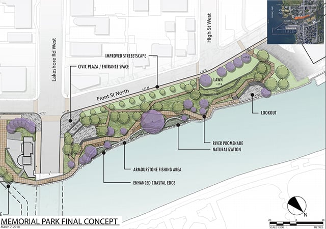
The park will boast a meandering river promenade that will provide access to lookout points and fishing areas, as well as a small civic space that will allow residents and visitors to relax and watch rowing and canoeing.
The city says the plan calls for an improved streetscape (including the future Credit Valley Trail which will pass through the west side of this park) and on-street parking along the east edge of Front Street North to replace the existing in-park parking area.
At the meeting, planners said the next phase of the project will refine the final park concepts into detailed design and construction drawings. At this time, the city is still soliciting feedback and taking resident questions and concerns into consideration.
In order to proceed, council will need to approve the project’s budget.
If approved, shoreline construction could begin as early as 2022.
The entire project could take up to 10 years to complete.
To learn more, click here.
insauga's Editorial Standards and Policies advertising