
Mississauga City Council gets ready for ward boundary review
Published December 12, 2019 at 4:09 am
It’s almost time for one of the rather mundane exercises any municipal government of a large city has to consider–the ‘ward boundary review’.
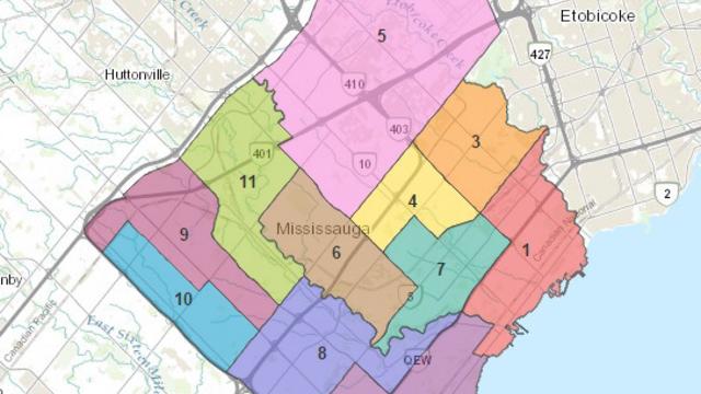
Mississauga is currently divided into 11 constituencies, known as wards, where one city councillor is elected to represent one ward. The last time a ward boundary review was done in Mississauga was just before the 2006 municipal election when the number of councillors went from 9 to 11 by dividing wards in the northwest corner of the city.
This current review was necessitated because of the population growth Mississauga has experienced in the past decade and more. As a result of that growth, not all the wards in the city have the same number of residents for every councillor, according to this staff report from the December 11 council meeting.
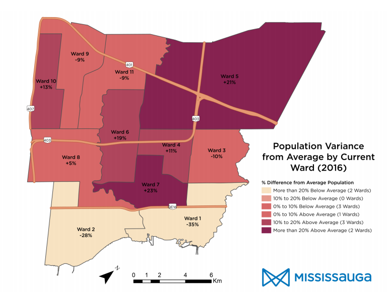
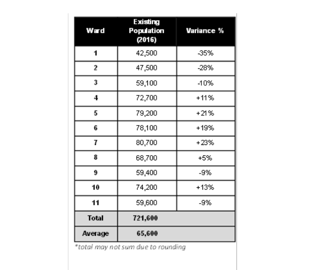
“The population distribution among the city’s 11 wards is unbalanced. Currently, 7 of the 11 wards are above or below the ideal threshold of 10 per cent variation from the average population (around 66,000 residents per ward). There are two that vary by more than 25 per cent from the average,” the report says.
Here are the ward population variances based on the 2016 census numbers:
Videos


A few years ago, a recommendation from staff was considered by adding another councillor in order to address the population growth and geographic disparity in Ward 5 by splitting it to create a new Ward 12. However, that study was more narrowly focused on just Ward 5 and didn’t take into account of all the city’s ward boundaries.
I also opined that the city should give wards names instead of numbering them to enhance the sense of community for residents being asked to vote, but I digress.
However, the population number is not the only factor taken into account when the city redraws ward boundaries for city councillors. Other considerations include:
-
Future ward populations, which are assessed every 10 years.
-
Use of natural and artificial features, such as Highways 401, 403, the Credit River and CN rail lines.
-
Impact on historical communities and communities of interest, such as ‘historic villages’ like Port Credit, Streetsville, Clarkson and Cooksville and growing areas like downtown, uptown (Hurontario and Eglinton), the waterfront and the Ninth Line lands.
-
Impact on the city’s 18 ratepayers associations and their divisions.
-
The number of businesses in each ward; the amount of employment can impact the complexity of issues a councillor must respond to within their ward.
-
Institutions and community facilities, such as community centres, post-secondary institutions and hospitals.
Staff will come back to council with three recommendations in January followed by public consultations from February to April 2020. A final scenario will be developed by April and it will be brought to council in May for consideration.
The proposed approaches for those scenarios will be based on either of the following:
-
Minor adjustments to the current 11 ward configuration, which would not significantly alter boundaries.
-
Aligning neighbourhoods, focusing on ‘communities of interest’ and aligning ‘high growth neighbourhoods’ into single wards.
-
Voter parity, proposing much more substantial changes to all wards, but minimal population variation. Natural and artificial boundaries would be considered in defining boundaries.
-
Matching city wards with provincial and federal ridings whereby the riding gets split in half, but that would mean adding a 12th councillor.
In June 2020, the notice and appeals period will begin, meaning if anyone has objections to the revised ward boundaries they can appeal to the Local Planning Appeal Tribunal (LPAT).
Residents Joe Horneck and Andrew Gassmann were at Council to speak on the ward boundary review; both men ran for city council in 2018. Gassmann, who placed second in Ward 7, said that ward needed to be split up from north to south because of the burgeoning population growth caused by condo development along Hurontario, saying it was impossible to effectively canvass the increasing number of highrises as a candidate.
Horneck, who ran a close race in Ward 6, brought up the idea of tying ward boundary reviews to federal census data so that Mississauga is not waiting over ten years to do changes, mentioning that by the time new ward boundaries are in effect for 2022, they would be using the census data from 2016, meaning the numbers would be six years out of date.
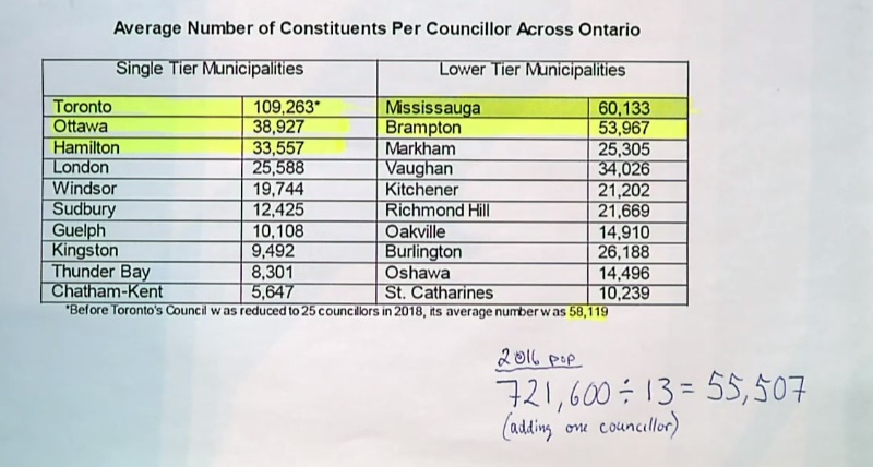
He also suggested a fourth map be considered on top of the city’s planned three recommendations to add a 12th councillor, pointing out if that was the case, Mississauga would still have only the second highest number of constituents per councillor across Ontario, only being overtaken by Toronto.
The final bylaw to change ward boundaries must be in force by December 31, 2021, in time for the 2022 municipal election.
insauga's Editorial Standards and Policies advertising