
How the Mississauga Transit Map From 1990 Has Changed
Published July 11, 2016 at 3:08 am
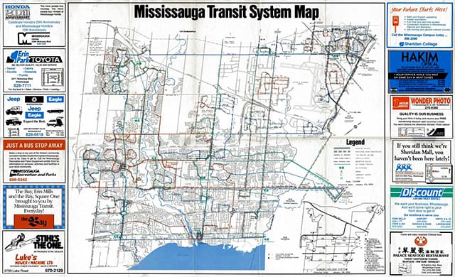
I’m a bit of a map fanatic, and these days I take time to collect maps of cities and countries showing their local jurisdictions, as well as some of their transit networks. So I was quite happily surprised when I came across this old map of Mississauga Transit from around 1990. My family and I came to Canada and settled in Mississauga around the summer of that year, and we definitely needed something like this when we first arrived in order to figure out how to get around our new home. There was no Google Maps or GPS, let alone smart phones back in those days!
Seeing that this is figuratively a window into Mississauga’s past, and being interested in history in general, I thought I’d make some observations and opine on a few things:
The Business Ads
Before the advent of Twitter, Facebook or even email, this was how businesses, institutions and government promoted themselves. Most of these businesses, particularly the dealerships, are still around today. I find it a tad amusing that businesses promoting automobile usage are advertising on material that promotes public transit use.
Business Name Changes
The Palace Seafood Restaurant is currently known as Emerald Chinese Restaurant. I guess in 1990 it was all about the seafood.
Apparently back in 1990 there was still a reason to go to Sheridan Mall, since they were advertising themselves as somewhere that had something new to showcase. I wasn’t around Mississauga before 1990, so I’m guessing this was a period when they were undergoing a name change. It obviously went through another name change again, because today it is known as the Sheridan Centre. Don’t get me wrong, Sheridan is a historic name in the history of Mississauga. “Sheridan” almost became the name of the budding municipality back in 1968 before the residents decided on “Mississauga.”
Now onto the map itself:
Service seems limited
Think back to 1990: Mississauga is barely 20 years old as a city, and it was still in the stages of the post-war suburban boom, which meant a larger demand on travel by automobile. Most of the major bus routes look as though they have a mind of their own, and it doesn’t seem like all roads lead to Square One. The major and semi-major roads are covered with some reaches into neighbourhoods, but as you can see, large swaths of Mississauga didn’t have anyone living there at the time, so they got bypassed. Speaking of which…
Ward 10 does not exist
Sorry Councillor Sue McFadden, but if you were running for office in 1990 you wouldn’t have had a constituency to run for. Churchill Meadows didn’t exist, and Lisgar was barely a community except for a few subdivisions. What would become Ward 10 was still under Ward 9 in the capable hands of Councillor Pat Saito (or whoever her predecessor was as my understanding is Pat Saito was elected in the 1991 municipal election).
The Pace of Development
The missing Ward 10 is indicative of the way the pace of development evolved in Mississauga since its inception as a city in 1974. In 1974, most of the southern portion of the city was well established and built out while the northern parts of Mississauga were the areas ripe for development — and not only in the Ward 9 and 10 areas, but also out by the northeastern corner of what is now Ward 6. That area now houses the Brae Ben Gold Course, but back then it was either nothing or a giant landfill. But this map really brings it home that Mississauga still had this abundance of cheap land, and in a little over two decades, all that land is developed with residential homes and other infrastructure, erasing the quaint rural life those areas once enjoyed. Even the tiny Meadowvale Village was tucked away up by Derry and Mavis back in 1990 is now surrounded by subdivisions.
UTM still using original name, Erindale College
You can see on the map that UTM was named Erindale College, which was its original moniker when it was first founded in 1965. It was renamed University of Toronto Mississauga in 1998, the year it also upgraded from being a college to a university. Watch out for Sheridan College’s HMC down the road, as it is also seeking university status in the near future.
What hasn’t changed?
Malton still an island onto itself:
Whether it’s 1990, 2020, or even 2050, Malton is and forever will be a unique community onto itself apart from Mississauga. There may have been bus routes running up to provide service to Malton back then, and obviously service has increased there now, but there is no denying that it is a unique place up in the northern part of Mississauga, with a culture onto itself. For a more in-depth look of the neighbourhood of Malton, please read this from a recent Jane’s Walk conducted by local citizens interested in urban exploration.
The most pointless bus route then? Surely the most pointless bus route now
In all fairness, maybe not. Back in 1990, South Common mall was a much more active shopping centre — I can attest to that personally. So maybe there was more need to have a transit connection for the surrounding neighbourhoods there. Now that South Common isn’t much of a happening place, and getting closer to dead mall status (at least the original mall itself), I’m not sure how relevant the No. 47 Ridgeway Loop is. But more importantly, I can’t believe that for over 25 years or even longer, a bus route that looks like a certain part of the male anatomy has managed to survive all this time and MiWay officials haven’t realized what it looks like on the map, or from a bird’s eye view…
In conclusion, if I have to offer words of wisdom to the next generation….collect maps and study them. You never know what interesting little tidbits of information you might learn and dazzle your family and friends with!
