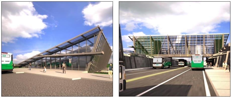
Here’s What’s Happening With Getting Public Transit on the 407 in Brampton Preferred Region How does this work? Brampton | Ontario | Latest News | Published January 26, 2018 at 10:29 pm </span></p><div> <div align="center" data-freestar-ad="__300x250 __300x250" id="insauga.com_Direct" style="padding-bottom: 15px;"> <script data-cfasync="false" type="text/javascript"> freestar.config.enabled_slots.push({ placementName: "insauga.com_Direct", slotId: "insauga.com_Direct" }); </script> </div></div> <p>Two years ago, inbrampton.com <a href="https://www.inbrampton.com/would-you-like-to-see-public-transit-on-the-407-in-brampton">reported on a proposal</a> to have public transit running alongside Highway 407, from Burlington all the way out into Durham Region. Now, proposed stations have been outlined!</p><div class="stn-in-content-video"> <div id="FreeStarVideoAdContainer"> <div id="freestar-video-parent"> <div id="freestar-video-child"></div> </div> </div> </div> <p>Below is a map of the section around Peel and York Region.<img decoding="async" src="https://lh5.googleusercontent.com/pcZ6Mc_5z-rS6uDxlkO1xUUUPb9r2gxOXgmd2UXWBRAqK6MZEpVL9xp1BlTNiy6Q_G5F8AoiuItc0RcCcqEv9EdZgOV1Zfufj0d0BbCX_gmfCm-3gRL8BFDdkuCu6UJQBsc9F17G"></p> <p>Below is a map of the entire route.</p><div> <div align="center" data-freestar-ad="__336x280 __728x250" id="insauga.com_InContent"> <script data-cfasync="false" type="text/javascript"> freestar.config.enabled_slots.push({ placementName: "insauga.com_InContent", slotId: "insauga.com_InContent" }); </script> </div></div> <p><img decoding="async" src="https://lh3.googleusercontent.com/ZkyiqHlO7svvNU2OdlRku2SredFKzkvrb0MDrG73BXjgmY64tmw8iAA4lNfqkEsQGbrmY8Y3yTEujG9N-zYmMlxz4CTq0dAFlgx60ljZcRJFRVxG-Lp9tOYfC6BRavoWZcvOeZ68"></p> <p>Following the initial presentation back in 2016, a second public presentation was held last week <a href="http://www.407transitway.com/hurontarioTo400/consultation.html">at the Greenbriar Recreation Centre</a> in Bramalea to provide additional information such as proposed designs for stations along the 407 Transitway.</p><div> <section class="video-slider"> <p><script type="text/javascript" class="teads" src="//a.teads.tv/page/215239/tag" async="true"></script></p> </section> </div> <p>First, this is a schematic of the proposed transit service to run alongside the 407.</p> <p><img decoding="async" src="https://lh3.googleusercontent.com/k35YJjS4hR9FI7UJhPxsmyEvqkn5hyMVIj3I7Fdz9weOuBf3K1eMidJJsDwiyy0ME9jWPUyqZ0rziKvtLuPaZ7bgCX7729u-dYQH3G5onHP7DG65tL1_lCOD-G6GNeBFcxEZMw_-"></p> <p>Spine services were defined as services that would operate exclusively on the Transitway, including express routes. The No-Transfer services, which are the white interlining areas, were designed to provide one seat rides between major nodes and residential areas. The operating speed between Transitway stations is estimated to be 100 km per hour.</p> <p>A number of nodes that will be serviced by transit include the following:</p> <ul> <li> <p>Urban growth centres in Brampton, Vaughan, Richmond Hill, Markham, Downtown Oshawa and Pickering.</p> </li> <li> <p>Universities and other post secondary institutions (York University, Durham College, and York U’s Markham and Keele campuses).</p> </li> <li> <p>Transit connections such as Brampton’s ZUM, Bramalea GO station, MiWay, York Region Transit and the future Hurontario LRT.</p> </li> </ul> <p>There is approximately 53 percent population and 57 percent of anticipated employment growth rate between 2011 to 2041 along the corridor, as shown in these graphics:</p> <p><img decoding="async" src="https://lh3.googleusercontent.com/VI54IWtHsH5iFGrpxyirqMwFDVmde77lhEV9n-5XgcJCluiFJa0V629Jvjd2C3W1Fq7-xfcXKNsnIMgAFBNme6MR8pmHG117DPgy8_xb7XivEsLn2mmZsf9zwqMLRD_1CW5uCuyv"></p> <p><img decoding="async" src="https://lh3.googleusercontent.com/M8NuexZyeLo2bh9KAZRMqWOiLTvIH9hXLMLlZmu9UyRjFxZOmuBkCJ-_iTNU_fNyMtNXftjN3tWqKbPhY_YVCvPPAgrcnqCrXRhByQDcn6SQklr98RaeORvwJBpmMU7nWyrbFNRj"></p> <p>A number of placards gave an indication of the proposed designs for some of these nodes stations. Here are the stations that are slated for Brampton and Peel Region.</p> <p><img decoding="async" src="https://lh5.googleusercontent.com/adbyLUPcew9A5FeQbgfUqbJuMhD0KZIHiXaTMEScx7CPNJ3HMsY5cUdJhRKR40dpafAnE8kGK38DC8zcQegXIipSpbWKCHdP4tgintr8Nrph65w71uZS1jRl0hx1sG1GRc8SsuCc"></p> <p>Situated at <a href="https://www.google.ca/maps/place/Vicksburgh+Dr,+Mississauga,+ON+L5W+1N4/@43.6491659,-79.7149873,17z/data=!3m1!4b1!4m5!3m4!1s0x882b3f95ce575521:0xe232edbab9b4a0f0!8m2!3d43.649162!4d-79.7127986">this intersection along Hurontario Street</a>, this node station will have almost 600 parking spaces, 10 accessible parking spots, 3 bus bays, bicycle shelters, and optimal connections with the future LRT. They also showed the preferred road alignment:<img decoding="async" src="https://lh5.googleusercontent.com/7onds-iL_BXLSodLzTDoT6TQT5g70lQe7AG6ocwq5j7koptbxmPgWxdiq8cFtlabC27vLc6uh01TWITJQqh8EtywjB6sFyFxdWSNnY-Wtf-hjqUHinVE3nlVj1IldFjuTSBVar8u"></p> <p>Next along the corridor, the Dixie node station will have 780 parking spaces. Cricket fields will not be impacted but there will be some expected impact on nearby soccer fields.</p> <p><img decoding="async" src="https://lh6.googleusercontent.com/48z2OtBHuLHo36TYjOJ6T4_bve9m9vIQhDXVKDpOc4slGCDA-Us1KH2KqMkVn3lSN7DGfRAYLFUehwvl2lxvHdT5INIp_Ndv4WnVv_U5mW7TC7-YJhSBPdcZd3PsSilz6TtxPWuq"></p> <p>And the preferred alignment:</p> <p><img decoding="async" src="https://lh3.googleusercontent.com/RHwdNaas4QswkiBQwCIFlfNIFQWj7VI1S8kOixFz1vH10kv7tsevLDL4yPNPMEjosgXEAegvTetqXUGuWd152BU9dAK4dv0vjbuJHBhlImScKNxZp7P7J1fuRXSU0PqAum147aVc"></p> <p>The proposed node station by Airport Road will have 560 parking spaces, with 10 accessibility spaces, 3 bus bays and bicycle shelters. There will be connections with Brampton and MiWay transit services.</p> <p><img decoding="async" src="https://lh5.googleusercontent.com/oeGowSqKBWcKc527abjzawM5x9UTls9_6SgSJHhkC2zD7nCcpiFSIaZ3ugBWCDzI0x-qiRm4BXf30mogWLgrlJ6Sg7scCb96pH43RqaiOhUh6YKgPZg4rGXrZ_O1kKA9ekF3fpsG"></p> <p>And the preferred alignment:</p> <p><img decoding="async" src="https://lh5.googleusercontent.com/ZIwiU16y4m4UFLAnW7nN5NFCr4i9V2ScE1LrBOwaaltiieHzLX5IcSKPBLnGYg4bvedgGyZjYRqgAbO1XwuoBrs5LY-fvQttAGFKEkYSpBH8OaUvp2DQol4Tg2ClRek0dl1ziDzN"></p> <p>From the above map, you can see there is also a proposed node station at the Goreway Drive and Steeles Avenue intersection, will have close to 800 parking spaces, and connections with Brampton transit services.</p> <p><img decoding="async" src="https://lh5.googleusercontent.com/jryBPEH7WuCgHoBJwF1rczVTE275AWgGEYBtlvENaNJ6pjPnvF5Pvc5MmdGqS7iZcScODQwLnhlIQ5lUrgpE5eAOOavY8wpvIXmAksL3vOz4SaTybH1c4-XHC30YW-FLyQD9jUWg"></p> <p>The rest of the corridor continues east through portions of York Region serviced by Highway 407. The entire presentation for the Peel section can be <a href="http://www.407transitway.com/hurontarioTo400/downloads/PIC2%20Presentation%20Panels.pdf">found here</a>.</p> <p>There will also be a fully grade separated transit facility on an exclusive right-of-way, running along the corridor. It will consist of 23.7 km of running way and several stations that will include parking facilities, transit integration and other amenities.</p> <p>Subject to the outcome of the study, the 407 Transitway will be implemented initially as Bus Rapid Transit (BRT) with the opportunity to convert to Light Rail Transit (LRT) in the future. But when I spoke to project staff and asked about how much this will cost, they said this is only the planning stage, and any firm price tags and who is paying for said project have yet to be determined.</p> <p>We’re all looking for better forms of transit, and a bus rapid transitway is no longer some idea on the book, but reality (see the Mississauga Transitway for instance). I’m not sure about any future plans to convert this corridor to an LRT, but a dedicated bus lane is definitely feasible.</p> <p>Would you ride a bus running alongside Highway 407 if it got you home or to work faster?</p> <p>Follow me on Twitter <em><strong>@thekantastic</strong></em></p> </html> <a href="https://www.insauga.com/editorial-guidelines" class='editorial-guidelines-link d-block mb-4'> INsauga's Editorial Standards and Policies </a> <div class="OUTBRAIN" data-widget-id="GS_1"></div> <div class='mb-5'></div> </article> </div> <div class='d-none d-lg-block col-lg-3'> <aside class="sidebar" role="complementary"> </aside> </div> </div> </div> </main> <div class='clearfix'></div> <footer class="footer mt-5"> <div class='container'> <div class='footer-top'> <nav class='local-links'> <h2>Local News</h2> <ul class='no-dots'> <li> <a href='https://durham.insauga.com/region/ajax/' >Ajax</a> </li> <li> <a href='https://www.insauga.com/region/brampton/' >Brampton</a> </li> <li> <a href='https://halton.insauga.com/region/burlington/' >Burlington</a> </li> <li> <a href='https://www.insauga.com/region/caledon/' >Caledon</a> </li> <li> <a href='https://www.insauga.com/region/canada/' >Canada</a> </li> <li> <a href='https://durham.insauga.com/region/clarington/' >Clarington</a> </li> <li> <a href='https://durham.insauga.com/' >Durham</a> </li> <li> <a href='https://halton.insauga.com/' >Halton</a> </li> <li> <a href='https://halton.insauga.com/region/halton-hills/' >Halton Hills</a> </li> <li> <a href='https://hamilton.insauga.com/' >Hamilton</a> </li> <li> <a href='https://niagara.insauga.com/region/lincoln/' >Lincoln</a> </li> <li> <a href='https://halton.insauga.com/region/milton/' >Milton</a> </li> <li> <a href='https://www.insauga.com/region/mississauga/' >Mississauga</a> </li> <li> <a href='https://niagara.insauga.com/' >Niagara</a> </li> <li> <a href='https://niagara.insauga.com/region/niagara-falls/' >Niagara Falls</a> </li> <li> <a href='https://niagara.insauga.com/region/niagara-on-the-lake/' >Niagara on the Lake</a> </li> <li> <a href='https://halton.insauga.com/region/oakville/' >Oakville</a> </li> <li> <a href='https://www.insauga.com/region/ontario/' >Ontario</a> </li> <li> <a href='https://durham.insauga.com/region/oshawa/' >Oshawa</a> </li> <li> <a href='https://durham.insauga.com/region/pickering/' >Pickering</a> </li> <li> <a href='https://niagara.insauga.com/region/st-catharines/' >St Catharines</a> </li> <li> <a href='https://www.insauga.com/region/toronto/' >Toronto</a> </li> <li> <a href='https://niagara.insauga.com/region/welland/' >Welland</a> </li> <li> <a href='https://durham.insauga.com/region/whitby/' >Whitby</a> </li> </ul> </nav> <div class="menu-footer-container"><ul id="menu-footer" class="menu"><li id="menu-item-174" class="menu-item menu-item-type-post_type menu-item-object-page menu-item-174"><a href="https://www.insauga.com/about/">About</a></li> <li id="menu-item-176" class="menu-item menu-item-type-post_type menu-item-object-page menu-item-176"><a href="https://www.insauga.com/contact/">Contact</a></li> <li id="menu-item-175" class="menu-item menu-item-type-post_type menu-item-object-page menu-item-175"><a href="https://www.insauga.com/advertise/">Advertise</a></li> <li id="menu-item-177" class="menu-item menu-item-type-post_type_archive menu-item-object-careers menu-item-177"><a href="https://www.insauga.com/careers/">Careers</a></li> <li id="menu-item-178" class="menu-item menu-item-type-post_type menu-item-object-page menu-item-178"><a href="https://www.insauga.com/editorial-guidelines/">Editorial Guidelines</a></li> <li id="menu-item-616344" class="menu-item menu-item-type-custom menu-item-object-custom menu-item-616344"><a target="_blank" rel="noopener" href="https://www.yourcitywithin.com/">YourCityWithIN</a></li> </ul></div> <div class='social-links'> <a href="https://www.instagram.com/insauga/" target="_blank"> <i class="fab fa-instagram"></i> <span class='sr-only'>instagram</span> </a> <a href="https://vimeo.com/insauga" target="_blank"> <i class="fab fa-vimeo-v"></i> <span class='sr-only'>vimeo-v</span> </a> <a href="https://www.facebook.com/insauga" target="_blank"> <i class="fab fa-facebook-f"></i> <span class='sr-only'>facebook-f</span> </a> <a href="https://twitter.com/insauga" target="_blank"> <i class="fab fa-twitter"></i> <span class='sr-only'>twitter</span> </a> <a href="https://www.youtube.com/channel/UClbB81tMIIeAYfDU4EkrdDQ" target="_blank"> <i class="fab fa-youtube"></i> <span class='sr-only'>youtube</span> </a> <a href="https://www.tiktok.com/@insauga" target="_blank"> <i class="fab fa-tiktok"></i> <span class='sr-only'>tiktok</span> </a> </div> </div> <div class='footer-bottom'> <p class='copyright'> © Copyright 2024 INsauga </p> <div class="menu-footer-bottom-container"><ul id="menu-footer-bottom" class="menu"><li id="menu-item-256638" class="menu-item menu-item-type-post_type menu-item-object-page menu-item-privacy-policy menu-item-256638"><a rel="privacy-policy" href="https://www.insauga.com/privacy-policy/">Privacy Policy</a></li> <li id="menu-item-256639" class="menu-item menu-item-type-post_type menu-item-object-page menu-item-256639"><a href="https://www.insauga.com/terms-of-use/">Terms of Use</a></li> </ul></div> </div> </div> </footer> <div id='sub-footer-slot' class='ad-slot'> <div class='footer-slot-inner'> </div> </div> <div class='mobile-sticky-subscribe'> <button class='close'> <span class='fal fa-times'></span> </button> <p class='description'>Subscribe now to receive our daily email of today's top stories in your city!</p> <form class="newsletter-subscribe-form"> <input type='email' class='newsletter-email-address' placeholder='Email Address'/> <input type='submit' value='Subscribe' class='newsletter-form-submit' /> </form></div> <div id="subscribe-modal" class="modal" tabindex="-1" role="dialog"> <div class="modal-dialog" role="document"> <div class="modal-content"> <div class="modal-header"> <button type="button" class="close" data-dismiss="modal" aria-label="Close"> <span class='fal fa-times'></span> </button> <p class='description'>Subscribe now to receive our daily email of today's top stories in your city!</p> </div> <div class="modal-body"> <div class='subscribe-form'> <div class='loading-spinner'> <span class='fa fa-cog fa-spin'></span> </div> <span class='error-msg'></span> <input type='email' class='newsletter-email-address' placeholder='Email Address Here'/> <div class='region-checkboxes'> <div class='region-checkbox-group'> <input type='checkbox' name="mississauga" id="subscribe-checkbox-mississauga"/> <label for="subscribe-checkbox-mississauga">Mississauga</label> </div> <div class='region-checkbox-group'> <input type='checkbox' name="hamilton" id="subscribe-checkbox-hamilton"/> <label for="subscribe-checkbox-hamilton">Hamilton</label> </div> <div class='region-checkbox-group'> <input type='checkbox' name="brampton" id="subscribe-checkbox-brampton"/> <label for="subscribe-checkbox-brampton">Brampton</label> </div> <div class='region-checkbox-group'> <input type='checkbox' name="halton" id="subscribe-checkbox-halton"/> <label for="subscribe-checkbox-halton">Halton</label> </div> <div class='region-checkbox-group'> <input type='checkbox' name="durham" id="subscribe-checkbox-durham"/> <label for="subscribe-checkbox-durham">Durham</label> </div> <div class='region-checkbox-group'> <input type='checkbox' name="niagara" id="subscribe-checkbox-niagara"/> <label for="subscribe-checkbox-niagara">Niagara</label> </div> <div class='region-checkbox-group'> <input type='checkbox' name="toronto" id="subscribe-checkbox-toronto"/> <label for="subscribe-checkbox-toronto">Toronto</label> </div> </div> <button class='subscribe-submit'> Subscribe Now! </button> </div> </div> </div> </div> </div> <script type="module"> import { Workbox } from "https:\/\/www.insauga.com\/wp-content\/plugins\/pwa\/wp-includes\/js\/workbox-v6.5.3\/workbox-window.prod.js"; if ( 'serviceWorker' in navigator ) { window.wp = window.wp || {}; window.wp.serviceWorkerWindow = new Workbox( "https:\/\/www.insauga.com\/wp.serviceworker", {"scope":"\/"} ); window.wp.serviceWorkerWindow.register(); } </script> <script type="text/javascript" src="https://www.insauga.com/wp-content/plugins/wp-tiktok-feed/assets/frontend/swiper/swiper.min.js?ver=4.4.0" id="swiper-js"></script> <script type="text/javascript" src="https://www.insauga.com/wp-includes/js/imagesloaded.min.js?ver=5.0.0" id="imagesloaded-js"></script> <script type="text/javascript" src="https://www.insauga.com/wp-includes/js/masonry.min.js?ver=4.2.2" id="masonry-js"></script> <script type="text/javascript" id="simplistics-slider-js-js-extra"> /* <![CDATA[ */ var slider_ajax = {"ajax_url":"https:\/\/www.insauga.com\/wp-admin\/admin-ajax.php","nonce":"0e3ab75d93"}; /* ]]> */ </script> <script type="text/javascript" src="https://www.insauga.com/wp-content/plugins/simplistics-slider/assets/simplistics-slider.js?ver=2.0.2" id="simplistics-slider-js-js"></script> <script type="text/javascript" src="https://www.insauga.com/wp-content/themes/insauga/assets/dist/lib.js?ver=8949c83e" id="theme-lib-js"></script> <script type="text/javascript" id="theme-main-js-extra"> /* <![CDATA[ */ var ThemeJS = {"Variables":{"Ajax":{"url":"https:\/\/www.insauga.com\/wp-admin\/admin-ajax.php","nonce":"a2a45e5b68","loadTime":"2024-10-24 08:42:29"},"testMode":false,"region":"mississauga","prompt_action_message":"We'd like to show you notifications for the latest news and updates.","dataLayer":{"topicCategory":"Latest News","provinceName":"Ontario","cityName":"Brampton"},"internal_domains":["www.insauga.com","halton.insauga.com","hamilton.insauga.com","durham.insauga.com","niagara.insauga.com"],"sliderArgs":{"max_featured":"5","slide_timer":"4000"}}}; /* ]]> */ </script> <script type="text/javascript" src="https://www.insauga.com/wp-content/themes/insauga/assets/dist/main.js?ver=4d6b617a" id="theme-main-js"></script> <script type="text/javascript" src="https://www.insauga.com/wp-content/themes/insauga/assets/dist/pages/single-post.js?ver=5ee38e84" id="theme-single-post-js"></script> <script type="text/javascript" src="https://polyfill.io/v2/polyfill.min.js?features=IntersectionObserver" id="intersection-observer-polyfill-js"></script> <script type="text/javascript" src="https://cdn.onesignal.com/sdks/OneSignalSDK.js?ver=1.0.0" id="remote_sdk-js" async="async" data-wp-strategy="async"></script> </body> </html> <!-- Page cached by LiteSpeed Cache 6.5.0.2 on 2024-10-24 08:42:29 -->