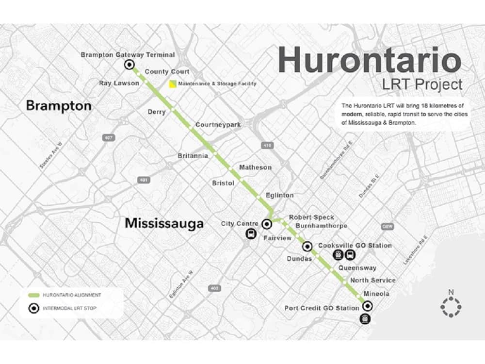
Crews working on a $1.4-billion light rail transit (LRT) route that will run from the south end of Mississauga north into Brampton are completing tasks around two major creeks in Mississauga in an effort to prevent devastating local floods in the future.
Officials with Metrolinx, the provincial agency overseeing work on the 18-kilometre Hazel McCallion LRT, say both the 100-year-old Mary Fix Creek and Etobicoke Creek are being restored and revitalized as part of the massive project.
“Not only is their restoration beneficial in enhancing habitat for local wildlife, but also for future flood risk, particularly at Mary Fix Creek,” said Mobilinx environmental manager Richard Booth.
Mobilinx is the constructor of the 19-stop transit route, which is expected to be completed in fall 2024.
Project officials continue, noting that the creeks are used as a natural flood management system as they reduce the flow of water prior to it reaching larger waterways.
“They offer a sustainable approach to managing and reducing the impacts of floods,” a Metrolinx spokesperson said in a project update today (Sept. 6). “Creek networks are very beneficial to the environment and provide areas for species and habitats to thrive.
“These waterways provide important flood protection and prevent soil erosion in the local areas in Brampton and Mississauga.”
Flood walls being built along the new LRT line take future climate risks into account, officials say. And the Hazel McCallion LRT “…is being constructed in a manner that is adaptable and resilient to future environmental conditions.”
(Photo: Metrolinx)
Not to mention, Metrolinx adds, the line will operate with clean, electrically powered light rail vehicles that produce near zero emissions.
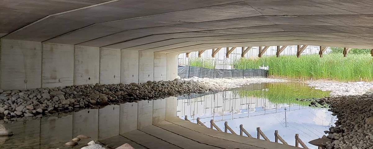
Much work this summer has focused on a section of century-old Mary Fix Creek near Port Credit GO station, the starting point of the LRT route.
“On the east end of the creek, construction on flood walls is underway. The team has redesigned the canal so that it’s wider, with higher flood walls. This way, it will have more protection against weather impacts,” project leaders said in early August.
“While flood walls are in construction, crews have ensured that work does not damage the creek. Sandbags are used to divert Mary Fix Creek to one side, allowing construction of the flood walls to continue without disturbing water flow.”
Named for a local pioneer, Mary Fix Creek flows from the Mavis Rd./Eglinton Ave. area in central Mississauga, then parallel to Hurontario St. south of the QEW before emptying into the Credit River at the CN bridge in Port Credit.
“This creek plays an important role in the city’s water infrastructure,” Metrolinx said, noting work crews are using extreme care around the creek.
“The creek provides vital flood protection and prevents soil erosion in the Port Credit area.”
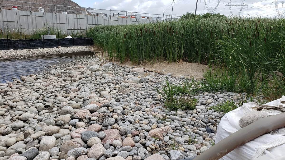
The new creek bed is designed to handle a 100-year-flood, which could have been devastating to the local area, Metrolinx says. As part of this, the creek infrastructure is being widened and deepened.
“As part of our restoration plans, crews will plant native trees, shrubs and plants to enhance local biodiversity and help restore a natural heritage system,” said Booth. “It’s nice to see many birds and other wildlife species using the new areas already”.
A new concrete flood channel has been installed between Hurontario St. and to just west of the GO station parking lot. New bridges to the GO parking area have also been constructed.
Metrolinx says creek channel reconstruction is now in the final stages on the section of the creek that runs parallel to the west side of Hurontario St. from just south of Oriole Dr. to the GO tracks.
Similar work is ongoing at Etobicoke Creek, which runs, in part, to the immediate west of Pearson Airport in Mississauga.
PollView All
WIN A $100 GIFT CARD
Subscribe to INsauga’s daily email newsletter for a chance to win a $100 Amazon gift card.